


India, a vast and diverse nation located in South Asia, boasts a distinctive political landscape. The country is divided into 28 states and 8 union territories, each with its own administrative and political structure. The political map of India showcases these regions, highlighting the boundaries and capitals of each state and union territory.
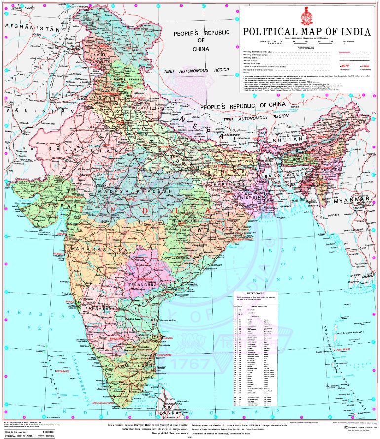
Here is an overview of the key regions on India’s political map:
| Region | Capital | Area (sq. km) | Population (Approx.) |
|---|---|---|---|
| States | |||
| Andhra Pradesh | Amaravati | 162,968 | 54 million |
| Arunachal Pradesh | Itanagar | 83,743 | 1.4 million |
| Assam | Dispur | 78,550 | 35 million |
| Bihar | Patna | 94,163 | 125 million |
| Chhattisgarh | Raipur | 135,194 | 29 million |
| Goa | Panaji | 3,702 | 1.5 million |
| Gujarat | Gandhinagar | 196,024 | 63 million |
| Haryana | Chandigarh | 44,212 | 28 million |
| Himachal Pradesh | Shimla | 55,673 | 7 million |
| Jharkhand | Ranchi | 79,714 | 38 million |
| Karnataka | Bengaluru | 191,791 | 70 million |
| Kerala | Thiruvananthapuram | 38,863 | 35 million |
| Madhya Pradesh | Bhopal | 308,245 | 82 million |
| Maharashtra | Mumbai | 307,713 | 125 million |
| Manipur | Imphal | 22,327 | 3 million |
| Meghalaya | Shillong | 22,720 | 3 million |
| Mizoram | Aizawl | 21,081 | 1.1 million |
| Nagaland | Kohima | 16,579 | 2.2 million |
| Odisha | Bhubaneswar | 155,707 | 46 million |
| Punjab | Chandigarh | 50,362 | 30 million |
| Rajasthan | Jaipur | 342,239 | 81 million |
| Sikkim | Gangtok | 7,096 | 0.6 million |
| Tamil Nadu | Chennai | 130,060 | 72 million |
| Telangana | Hyderabad | 112,077 | 39 million |
| Tripura | Agartala | 10,491 | 4 million |
| Uttar Pradesh | Lucknow | 243,290 | 220 million |
| Uttarakhand | Dehradun | 53,483 | 11 million |
| West Bengal | Kolkata | 88,752 | 97 million |
| Union Territories | |||
| Andaman and Nicobar Islands | Port Blair | 8,249 | 0.4 million |
| Chandigarh | Chandigarh | 114 | 1.1 million |
| Dadra and Nagar Haveli and Daman and Diu | Daman | 603 | 0.4 million |
| Lakshadweep | Kavaratti | 32 | 0.07 million |
| Delhi | New Delhi | 1,483 | 20 million |
| Puducherry | Puducherry | 479 | 1.2 million |
| Jammu and Kashmir | Srinagar (Summer), Jammu (Winter) | 222,236 | 13 million |
| Ladakh | Leh | 59,146 | 0.3 million |
This political map of India showcases the diverse cultural, geographical, and political landscape of the country, each state and union territory contributing to India’s rich tapestry. Please note that political boundaries and administrative divisions may change over time, so it’s essential to refer to updated maps and official sources for the latest information.
